Posts

Sint Maarten

Image
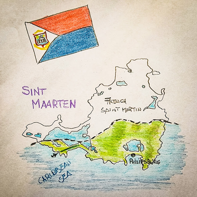
Sint Maarten is a constituent country of the Kingdom of the Netherland located on the south of a Caribbean Island shared with France. The Dutch territory covers the 40% of the island where lives little more than 40,000 people. The island was divided by the Treaty of Condordia in 1648 and despite the border changed sixteen times due to fights, the sharing is still in place till today. Cotton, tobacco and sugar plantation had been the main island income till after the WWII, when in the 50s the iconic International Airport was opened and the tourism business took off. Today the island economy is based on tourism, employing 80% of the population. Cruise ships and luxurious hotel resorts are the main type of tourism sources. The island location is exposed to the hurricanes season and it has been hit more then ones with the last in 2017 causing extensive damages to 70% of the houses and loss of lives. The real estate opportunities are almost exclusively top high end villas and th

Sint Eustatius

Image
Sint Eustatius, also known as Statia, is an island of the Caribbean West Indies and it is a special municipality of The Netherlands, like Saba and Bonaire. Statia is located in between Saba in the North and Saint Kitts in the south and has of only 21 square Km where lives little more than 3,000 people. In its history, from the 17th century the island changed hands 21 times between the Netherlands, France and Britain but most of the time it was under Dutch ruling. In the 18th century, Sint Eustatius was the most important and richest settlement in the Carribean; The Golden Rock was its nickname and the population reached 30,000. The main and most profitable business was the selling of weapons and ammunitions to any interested party, and at the that time countries were almost continuously fighting each other.   The island has also a place in the American history thanks to the “First Salute”: in 1776 the American ship Andrew Doria was approaching Sint Eustatius to purchase munitions and

Saint Vincent and the Grenadines

Image
Saint Vincent and the Grenadines is the island country of the Lesser Antilles laying between Saint Lucia on the North and Grenada on the South. The territory is composed by the main island of Saint Vincent with the capital Kingstown and a chain of 32 smaller islands many of which are inhabitated by a total population of 110,000 people. After an intial period when the islands were under French control, they has been maintly a British colony till the 1979 when they gained full indipendency. Nowadays Saint Vincent is a parlamentary democarcy and a constututional monarchy with Elizabeth II as Queen. Since its indipendance, the state had political stability without any major issues. Saint Vincent is a volcanic island with moist forest while southern islands has dryer forest ecosystems. In April 2021 the main volcano La Soufriere erupted, 16,000 people had to be evaquated and ashes covered part of the island. Climate is the typical tropical one, hot and humid with dry season from December to

Saint Lucia

Image
  Saint Lucia is an island country in the easter Caribbean where the Atlantic Ocean starts. The island surface is 617 square Kilometers where lives a population of around 180,000 people. The French were the first European to live and rule on the island till 1663, when England took it over for few years. After that there was a continuous change of power between the two counties, in total there were 14 changes in 150 years. In 1814, the British gain the definitive control which lasted until the island obtained the independence in 1979. Nowadays Saint Lucia is a two parties parliamentary democracy part of the Commonwealth real with the Elizabeth II as Queen of Saint Lucia. Geographically it is a volcanic island, one of the most mountainous of all the Caribbean, with tropical rainforest climate and the consequent two typical seasons: wet from June to December and dry from January to May. Qualibou is the name of the volcanic area where there are active sulfur springs which are o

Saint Kitts and Nevis

Image
The official name of Saint Kitts and Nevis island country is Federation of Saint Christopher and Nevis. The territory consists of two main islands located in the Leeward Islands of the Lesser Antilles. With a population slightly over 50,000 people and a surface of 261 square kilometres , Saint Kitts and Nevis is the smallest sovereign stated in the Western hemisphere. The islands were among the first to be colonized by Europeans and has been for long time a English and French settlement with a short period under Spain, until the 18th century when France renounced the control on the islands which became part of the British Kingdom. Saint Kitts and Nevis gain the full independence in 1983 and today it is a constitutional monarchy with Queen Elizabeth II as head of State. Basseterre is the capital. Both the islands are of volcanic origin and are covered by tropical rainforest, the costs are mostly flat which is where the vast majority of the population lives. Since  1970s, tourism saw a c

Saba

Image
  Saba is the smallest special municipality of The Netherlands and a small Caribbean island of 13 square kilometres where less than 2000 people are living permanently. Located in the northern Leeward islands of the West Indies, Saba is essentially composed by the potentially active volcano Mount Scenery which reaches 887 meters of altitude. Historically since the 17 th century, the island has always been under Dutch dominion apart from a period of 150 years under the British Kingdom which ended at the beginning of the 19 th century. During the British period, Saba was a hideout for Jamaican pirates often joined by English people who were send to the island because considered “undesirable” by the homeland authorities. After the Dutch regain control of the island in the 1816, the legitimate trading and sailing become the main activities till when stating in the 1960s tourism was steadily growing importance also thanks to the construction of an airport and a vessel pear. Nowadays touris

Jamaica

Image
  Jamaica is one of the most famous island countries in the Caribbean thanks to its history, nature, rum and lifestyle but also to popular Jamaicans such as Bob Marley and Usain Bolt. The Island is located 145 km south of Cuba and 191 Km west of Hispaniola and after them, it is the third largest one of the Caribbean Under Spanish domain till 1655 when the island was conquered by British who renamed it Jamaica. During the English period, Jamaica was leading the sugar export with its plantations.  Independent since 1962, today Jamaica has a population of almost 3 million people, a stable democratic government with a constitutional monarchy headed by Elizabeth II as Queen of Jamaica. In the last decade, the island saw an important economic growth and a general improvement of life quality. Mining, agriculture and tourism are the main pillars of the Jamaican economy. With an average of 4,3 millions visitors a year, in 2019 tourism accounted for 20% of the Country GDP with a positive trend